Seabed
Jump to navigation
Jump to search

The seabed round Gozo and Comino in Malta in Minecraft is the real sea floor, measured in a 2012 survey of the waters round the islands. Vanilla Minecraft makes up its oceans. Here, every reef, drop-off, channel and sandy bay is where it is in real life, at its real depth, out to about 1.85 km from the coast.
How it differs from vanilla
- Real depths, 1:1. One block is one metre all the way down to 200 m. The shallow bays are a few metres deep and further out the sea floor drops past 200 m, where vanilla oceans are rarely deeper than 30 blocks.
- Real shapes. Underwater cliffs, reefs, boulder fields and channels come from the survey, at a detail of 2 m. Vanilla sea floors are smooth rolling hills.
- Seagrass where it really grows. Seagrass meadows (the Mediterranean's Posidonia) cover the sea floor between about 3 and 35 m deep, and in shallow water the survey's own photos decide where there is sand and where there is seagrass.
- Rock layers under water. Underwater walls show the same rock layers as the cliffs above them, at any depth.
- No magma blocks or bubble columns anywhere in Maltese waters.
- Maltese sea biomes with their own water colours (see below).
- More dolphins off Dwejra. In the waters round Dwejra, dolphins come in pods of 2 to 4 and are about 13 times more common than in the rest of the sea.
Sea biomes
| Biome (F3 screen) | Where | What it is like |
|---|---|---|
maltamc:posidonia_meadows |
shallow water with seagrass beds | lukewarm ocean, blue-green water, dense seagrass |
maltamc:bahar_sea |
the open sea near the coast | lukewarm ocean, clear blue water, sand, rock and patchy seagrass |
maltamc:fond_deep_sea |
deeper than about 30 m | deep lukewarm ocean, the same blue at the surface, darker below |
maltamc:bejn_blue_lagoon |
the Blue Lagoon between Comino and Cominotto | warm ocean, bright turquoise water over white sand, with some coral |
maltamc:qawra_inland_sea |
the Inland Sea at Dwejra | turquoise water, sand and pebbles, no seagrass or coral |
maltamc:zerqa_blue_hole |
the Blue Hole at Dwejra | dark blue water, gravel floor, bare rock walls |
maltamc:dwejra_… |
the sea round Dwejra | the same as the three open-sea biomes, but with many more dolphins |
Shipwrecks and warm ocean ruins turn up in the open sea, as in vanilla.
Depths
| What | In the world |
|---|---|
| Sea level | y 63 |
| Down to 200 m | exactly 1:1, from the survey |
| Deeper than 200 m | squeezed, so that it fits above the bottom of the world: a real 300 m is about 221 blocks |
| Deepest sea floor | below y −150 in places, south-west of Gozo |
| Close to the shore | the survey doesn't reach the last 25 m or so before the rocks, so the sea floor there is modelled to join the two |
Where to see it
| Place | What you see |
|---|---|
| Crocodile Rock, off Dwejra Point | a plateau ending in a sheer underwater wall |
| Seaward side of Fungus Rock | the sea floor drops to about 60 m within 100 m of the rock |
| Dwejra Bay | sand and seagrass meadows, 8–10 m deep |
| The Blue Lagoon, Comino | white sand, seagrass and coral in very shallow turquoise water |
Coordinates
- Crocodile Rock wall (under water):
/tp @s -17285 54 -13430 - Seaward side of Fungus Rock:
/tp @s -17310 63 -13000 - Dwejra Bay (under water):
/tp @s -17045 56 -13040 - The Blue Lagoon, from above:
/tp @s -5185 142 -9205
-
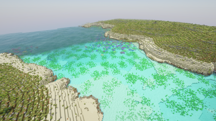 The Blue Lagoon, Comino
 -
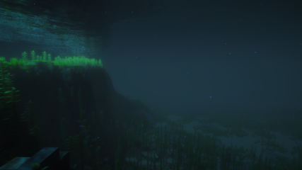 The underwater wall at Crocodile Rock
 -
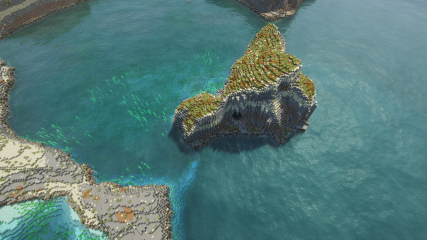 Seagrass and sand round Fungus Rock


Sources
- Sea floor: the 2012 seabed survey of the Maltese islands (an EU-funded survey, published in the University of Malta's 3-D viewer). It combines a laser flown from the air for shallow water (down to about 54 m) and sonar from a ship for deeper water.
- Sand and seagrass in shallow water: the colours of the same survey's aerial photos.
- Beyond the survey and next to the shore: modelled from coarser sea charts (EMODnet) and joined smoothly to the survey.
Trivia
- The survey holds about 776 million measured points of sea floor.
See also
- Dwejra: the dive sites at Crocodile Rock, Fungus Rock and the Blue Hole
- Blue Hole and Inland Sea: the two saltwater pools with their own biomes
- Rock layers: the rock in the underwater walls