Rock layers
Jump to navigation
Jump to search

Under every hill and cliff in Malta in Minecraft are Malta's real rock layers, taken from the official geological map. Vanilla Minecraft fills the ground with stone, granite, diorite and andesite at random. Here, the rock you see in a cliff, or dig through in a mine, depends on where you are and how deep you go, just as on the real islands.
The five layers
From the top down, the islands are a stack of five layers. Not every layer is everywhere: on the hilltops you can find all five, while low ground and sea cliffs often show only the bottom two.
| Layer (top to bottom) | What it is | Main blocks | Thickness in the world |
|---|---|---|---|
| Upper Coralline Limestone | hard limestone that caps the flat-topped hills | stone, andesite, sandstone, smooth sandstone | varies by place |
| Greensand | a thin orange-brown sandstone | packed mud, terracotta | 1–12 m |
| Blue Clay | soft grey-blue clay that forms the slopes under the hilltops | clay, cyan, light grey and light blue terracotta | 10–70 m |
| Globigerina Limestone | soft pale limestone, the islands' building stone | sandstone, smooth sandstone, stone, tuff | 25–200 m |
| Lower Coralline Limestone | the oldest exposed rock: hard, grey, forms the sea cliffs | stone, dripstone block, smooth sandstone | down to y 0 |
Below the Lower Coralline, from about y 0 down, is vanilla deepslate.

How it differs from vanilla
- Layers, not blobs. Each layer follows the real contacts between the rock units on the geological map, with the real tilt and faults. A cliff shows the same layers wherever you look at it.
- Beds inside each layer. Each layer is split into beds (thin layers), with thicknesses taken from the map's descriptions. The lines between beds wobble slightly instead of being ruler-straight.
- Ores in every layer. Vanilla ores only grow in stone-like blocks. Here clay, packed mud and sandstone count too, so coal, iron and the rest turn up all the way through the stack.
- No granite or diorite on show. Any granite or diorite touching water near the sea floor turns into stone, so they don't show up as grey and white blobs that Malta's limestone coast doesn't have.
- A weathered band at the waterline (tuff, brown terracotta, mossy cobblestone, dripstone), taller on open headlands where the waves are bigger.
- Local colours. A few places have their own rock colours, matched to photos: the iron-stained walls of Wied il-Mielaħ, the whitish rock at Dwejra Point and the golden-brown cliffs round the Inland Sea.
Where to see them
| Place | Layer | What you see |
|---|---|---|
| Xagħra and Nadur plateaus | Upper Coralline | the flat hilltops, with grey stone and andesite a few blocks under the soil |
| Rim of the Xagħra plateau, above Wied il-Ħanaq | Greensand | a band of packed mud one block under the soil, with Blue Clay below it |
| Slopes under the Xagħra plateau | Blue Clay | bare clay and blue-grey terracotta at the surface |
| Santa Luċija, near Kerċem | Upper Globigerina | bare yellow sandstone, with a dark packed-mud marker line |
| Azure Window | Lower Globigerina | the pale platform round the arch |
| Cliffs north of Dwejra | Lower Coralline and Globigerina | grey banded Coralline for the lower two-thirds, pale Globigerina on top |
| Wied il-Mielaħ | Lower Coralline | iron-stained gorge walls |
| Fungus Rock | Lower Coralline | Coralline from the sea to the top |
Coordinates
- Xagħra plateau:
/tp @s -9743 170 -14167 - Nadur plateau:
/tp @s -7714 190 -12884 - Xagħra plateau rim (Greensand):
/tp @s -9371 145 -14185 - Slopes under the Xagħra plateau (Blue Clay):
/tp @s -10293 141 -13881 - Santa Luċija (Upper Globigerina):
/tp @s -14385 173 -12719 - Azure Window platform:
/tp @s -17250 80 -13630 - Cliffs north of Dwejra, from the sea:
/tp @s -17090 92 -14100 - Wied il-Mielaħ gorge:
/tp @s -15044 66 -16598 - Fungus Rock, from the cliffs to the south-east:
/tp @s -17027 105 -12898
-
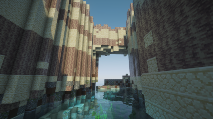 The gorge at Wied il-Mielaħ
 -
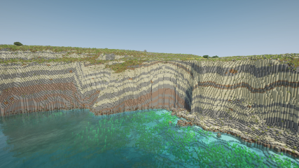 Ta' Ċenċ cliffs
 -
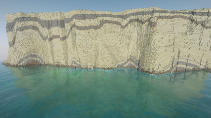 Sanap cliffs


Sources
- Source: the bedrock geology map of Malta, Gozo and Comino, mapped at member level (the subdivisions of each layer), with official descriptions of each unit's colour, bedding and thickness.
- Contacts: the height of each boundary is worked out from where the boundaries meet the ground on the map, once for all three islands, and fitted to the map's own boundary lines.
- Thickness: each layer is a thickness below the one above, kept within the real ranges for the Maltese islands.
- Colours: checked against photos of real cliffs. A few places have their own colours where photos show a clear difference.